River-runners live, more or less, by a measurement that everyday folks might not necessarily be very familiar with: streamflow, aka water flow, aka discharge. It’s commonly expressed in cubic feet per second, abbreviated as CFS.
But what does this USGS water flow measurement actually mean—and how should you use it to plan your rafting adventures? In this post, we’ll explore the concept of streamflow and link it to an understanding of white water rafting water levels—in particular, on the marvelous Arkansas River, our main “office” here at Echo Canyon River Expeditions, and among the finest rafting destinations in all of North America!
Why River Flow Data Matters
A lot of the very best whitewater rafting goes down on rivers that exhibit significant variation in streamflow over the course of the year. That’s certainly true in the American West, where most major rivers are predominantly fed by mountain snowmelt and thus reach their peak discharge anywhere between late winter and early or midsummer, coinciding with the pulse of that seasonal meltwater working its way down the drainage.
Here on the Arkansas River, peak streamflow typically hits sometime in June, but there’s a lot of year-to-year variation based on how much winter snowpack builds up in the mountains and the nature of the weather: The magnitude and timing of each year’s peak runoff intuitively depend on the snowpack’s snow-water equivalent (SWE) and prevailing temperature patterns.
Additionally, many prime rafting rivers, including the Arkansas, feature reservoirs that release timed flows, creating periods of high water. Heavy rains and cloudbursts can also cause temporary spikes in discharge.
Different flows create different challenges. High water increases speed and rapid intensity, while low water can expose more obstacles. Extremely low flows may make rafting impossible, just as peak flows can become too hazardous.
Rafting outfitters like Echo Canyon rely on river-flow data to schedule trips and assess difficulty, ensuring safe, fun, and feasible adventures for our guests.

Understanding CFS (Cubic Feet Per Second)
Cubic feet per second (CFS) measures how much water passes a point each second, calculated from river area × velocity
For a specific river, discharge helps determine whether the flow is low, average, or high—essential information for understanding its “raftability.” On the sections of the Arkansas River we run, we consider lower flows to be CFS levels of 650 and below, average flows to be roughly 650 to 2,000 CFS, and high water to be 2,000 CFS and above. Melt-off can produce maximum yearly flows on the Ark of 4,500 CFS or more!
Gage Height vs. Flow Rate: What’s the Difference?
When investigating USGS water flow data, you’ll encounter ‘gage height’ (also known as river stage, river height, or water level). This is the river surface’s height in feet above a streamgage’s reference point, the gage datum, located beneath the streambed; it is not the river’s depth.
Gage height, which indicates water level at a specific point rather than the entire river, is continuously measured at USGS streamgages. In contrast, hydrographers periodically calculate discharge, which better reflects a river’s overall condition and is more useful for rafters. The mathematical relationship between water level and discharge, derived from measurements across the full range of flows, is used to provide real-time flow data via a stage-discharge rating curve.


How to Interpret a USGS Stream Gauge
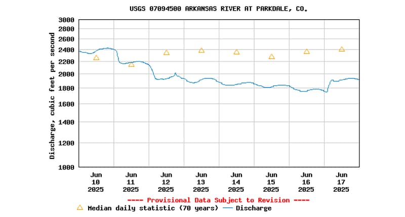
You can look at both the gage height and the streamflow/discharge of the Arkansas River near where we raft via the Parkdale, Colorado, USGS monitoring location. You can modify the graph to change the time period, which helps show the natural spikes and dips of both measurements. Hold your cursor over the graphed line to read specific measurements at a given time and day.
What’s a Safe Range for Beginners vs Experienced Rafters?
During a typical rafting season at Echo Canyon River Expeditions, Arkansas River flows increase with spring and early-summer snowmelt, then gradually decrease as summer advances. Our trips run from spring through fall, with peak activity between Memorial Day and Labor Day.
We offer trips across different CFS levels. The best water flow for rafting depends on a guest’s experience and ability. Experienced rafters can tackle flows above 2,000 CFS, while beginners and families usually prefer lower-flow trips.
In terms of the most broadly “accessible” and enjoyable water flow for rafting on the Arkansas, it’s often in the roughly 1,200-to-1,800 CFS range—typical midsummer conditions—but, again, more experienced and adventurous rafters may want to schedule a trip for the earlier-season peak discharge.
Lower flows are open to rafters of just about any condition and experience level (depending on the section), while higher flows can—but not necessarily will—be more consequential.
Arkansas River Water Flow Trends & What They Mean
A USGS stream chart enables you to track Arkansas River water level trends, including the increasing discharge from spring to early summer due to mountain snowmelt, and shorter, more erratic spikes from heavy rainfall or dam releases.
High water, exceeding 2,000 CFS, can intensify rapids and accelerate rafting. Conversely, lower flows may increase the technical challenge of a section due to more obstacles and require intricate maneuvering, potentially making rafting unfeasible at a certain point.

When and How Often to Check the Charts
As a guest, there’s not all that much need to check a river chart more than once a week, as normally water flows aren’t changing significantly enough that quickly. Remember, we’re monitoring CFS regularly here at Echo Canyon and making determinations as to trip timing and difficulty levels—and we know the Arkansas like the back of our hand!
Mobile applications and alerts from the USGS and select outfitters also offer convenient methods for monitoring river flow.
Planning Your Trip With the Rafting Pros at Echo Canyon
Having led rafting trips for guests of all ability levels since the late 1970s, Echo Canyon River Expeditions is an absolutely first-rate choice for adventures on the legendary Arkansas River. Safety’s our top priority, and we spend a lot of time studying river levels and flow rates, so trust our guides to be fully aware of what the Ark’s doing and what’s the best choice for you and your party when it comes to a rafting itinerary.
For expert guidance on river flow data and to plan a safe, unforgettable whitewater experience, connect with the rafting pros at Echo Canyon.
What Echo Canyon Experts Consider Before Launching a Trip:
- CFS level & forecast
- Gage height & trend
- Guest experience & comfort
- Seasonal snowmelt or rainfall
- River obstacles & known changes
